Drone Thermal Imaging Explained and How It Can Help You.

By Media4You · Approximately 9 minutes to read.
A roof can look perfectly ordinary while giving away clues about escaping heat. A solar panel can appear undamaged while part of it runs noticeably hotter than its neighbours. Across a large site, those differences can be difficult to find from the ground.
Thermal imagery makes these temperature patterns visible, giving people a clearer idea of where to investigate and what to do next.
At Media4You, we use the DJI Matrice 4T to capture thermal imagery alongside normal photographs and video. Our service supports homeowners and organisations across the Isle of Wight and Hampshire, with other UK locations considered by arrangement.
Here is how it works, where it can help, and what makes the results useful.
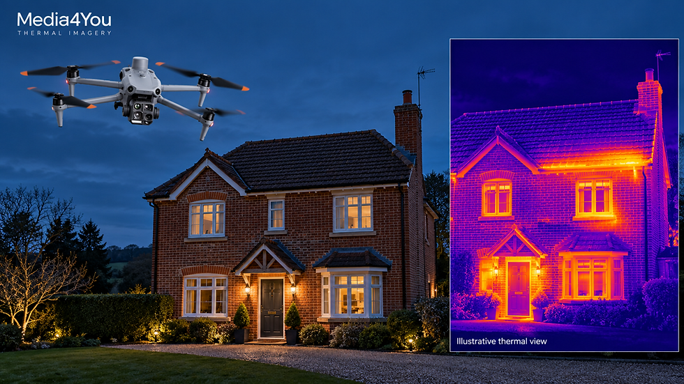
Aerial thermal imagery can highlight surface temperature patterns for closer investigation. AI-generated illustration; not imagery from a client inspection.
What thermal imagery actually shows
Objects around us give off infrared radiation. Our eyes cannot see it, but a thermal camera detects it and creates an image showing differences in apparent surface temperature. The process is also called thermography.
In a familiar thermal colour palette, cooler areas might appear purple and warmer areas yellow. Other palettes use black and white. The colours are a display choice: they help us recognise patterns, rather than showing what an object looks like in ordinary light.
A bright patch deserves attention, but its meaning depends on the surface, surroundings and temperature scale. It could reflect normal operation, sunlight, a reflection or a potential problem. Comparing it with similar nearby areas helps us decide whether it warrants investigation.
Thermal imagery provides evidence to interpret. A colour alone is never a diagnosis.
How our thermal drone works
Our Matrice 4T carries a thermal camera alongside its visible-light cameras. Its thermal sensor has a native resolution of 640 × 512 pixels and can capture radiometric images, which retain information for temperature analysis. [1]
That gives us two useful views of a location. Thermal imagery highlights a temperature pattern; a normal photograph helps identify the roof section, panel or other feature involved.
From the air, we can view accessible roof areas and upper elevations that are awkward to inspect from the ground. Flight distance and camera angle matter: a small feature needs enough thermal pixels to be assessed properly. Zooming into an image cannot recover detail that was never captured.
Where thermal imagery can help
Finding clues to heat loss in homes and commercial buildings
If a building is expensive to heat or certain rooms feel colder than others, an external thermal inspection can help highlight areas worth investigating. These may include unusual patterns around roof junctions, window surrounds or sections of the building fabric.
Some patterns can be associated with missing insulation, air leakage or thermal bridging, where heat travels more easily through part of the structure. Interpretation needs care because building materials and reflections can also create differences. [2]
For a homeowner, this can help focus a conversation with an insulation installer or building surveyor. For a facilities manager, it can help identify which areas across a larger property deserve closer attention.
An aerial inspection covers the surfaces the drone can see. An internal inspection or other investigation may also be needed to understand the cause. Thermal images alone cannot calculate an exact heating bill saving.
Checking solar panels for unusual temperature patterns
Solar panels can develop temperature differences that deserve further checks. A localised hot area may be associated with a cell problem, shading or contamination, while a broader pattern can suggest an issue affecting a larger part of the installation. [3]
Drone imagery helps relate these patterns to particular panels or sections of an array. Your installer or maintenance contractor can then investigate the relevant area and decide what testing or work is appropriate.
For example, if a rooftop system is producing less electricity than expected, a thermal inspection may help narrow down where to look. The cause still needs checking against visible imagery, system performance information and, where necessary, electrical tests.
This can be useful for household installations, farm buildings, commercial rooftops and larger solar sites. The inspection scope and achievable detail depend on the installation and access.

Thermal and visible imagery can help identify which solar panels need further checks. AI-generated illustration; the highlighted area is not a verified fault.
Supporting roof inspections and planned maintenance
Under suitable conditions, moisture within some roof constructions can change how the surface warms and cools. Thermal patterns can therefore help identify areas for closer investigation. They do not directly show water or prove the location of a leak. [10]
For a business, the practical benefit is a more focused maintenance discussion. A contractor may be able to investigate a particular roof area instead of starting with the whole building. Moisture testing or a physical inspection may still be required.
Where industrial equipment is visible and suitable for aerial inspection, thermal capture may also support specialist checks. The drone cannot inspect components hidden inside closed housings, and findings need assessment by someone competent in the equipment involved.
Assisting searches and emergency response
Thermal imagery can help distinguish people or animals from their surroundings, including in darkness. Combined with normal or zoom imagery, this can support an organised search or help responders understand a scene. The Matrice 4T is designed for applications including emergency response and public safety. [4]
Detection depends on the target being visible to the sensor and sufficiently different from its background. Dense vegetation, terrain and buildings can conceal a subject. A drone therefore adds another viewpoint to the search effort, with any operational support coordinated with those managing the incident.
What happens when you book a thermal operation
First, we establish the question. You might want to investigate a cold building, review a solar installation or collect imagery for a maintenance contractor. Tell us what concerns you and who will use the results. That helps define the capture and the output you need.
We then assess the site and conditions. Planning considers access, airspace, nearby people, obstacles and suitable flight positions. We also consider whether the expected weather and operating conditions will make the thermal information useful.
During the operation, we capture context as well as temperature patterns. Thermal and visible imagery help relate an observation to an identifiable part of the site. Where appropriate, additional views can help investigate whether an apparent anomaly changes with the viewing angle.
After capture, the findings are reviewed and presented within the agreed scope. Outputs can include selected thermal and visible images, annotations, location references and a written explanation. More detailed analysis or specialist interpretation should be agreed at the quotation stage.
The aim is to give you something you can understand and discuss with the person responsible for the next step.
Why timing and weather matter
Different thermal jobs need different conditions.
For building heat-loss investigations, there needs to be a useful temperature difference between indoors and outdoors. Cool conditions and a consistently heated building often help. External work is usually planned when direct sunlight and its lingering effects will not mask the patterns being investigated. Wind and rain can cool surfaces and reduce useful contrast. [5]
Solar inspections have different requirements. Panels normally need to be operating under sufficient, reasonably stable sunlight so that relevant differences can develop. An evening flight arranged for building heat loss is therefore a different task from an operational solar-panel inspection. [3][6]
Materials matter too. Shiny metal and glass can reflect infrared radiation from their surroundings. Accurate temperature assessment requires attention to these reflections, the material's emissivity—how effectively its surface emits infrared radiation—and factors such as distance. [7]
This is why a useful inspection starts with planning, and why rescheduling can sometimes produce a better result.
What thermal imagery cannot tell you on its own
Thermal cameras detect the surfaces facing them. They cannot see through solid walls or roofs, and ordinary window glass does not provide a thermal view into a room. A concealed issue may affect a visible surface temperature, but the camera records that surface effect. [8]
Temperature readings are estimates affected by the camera, settings, materials and conditions. The number displayed should be considered alongside those factors.
Equally, an area that looks normal during one visit is not proof that it has no defect. Some problems only produce a detectable pattern under particular conditions.
Thermal imagery can support decisions, but a building survey, electrical test or other specialist assessment may be needed before deciding on repairs or confirming compliance.
Turning the imagery into a useful next step
The value becomes clearest when an observation leads to a practical action: a roof section to investigate, a panel for an installer to test, or a junction to discuss with a building professional.
For homeowners, that can mean a clearer starting point before spending money on improvements. For companies, it can help prioritise maintenance, communicate concerns to contractors and keep a record for future comparison. Repeat inspections can be useful when conditions and capture methods are sufficiently comparable.
Drone access may also reduce the need for an initial visit at height, although hands-on inspection and repair can still require scaffolding or other access equipment.
At Media4You, we bring together thermal capture and visible imagery, with the scope shaped around your question. We are an Isle of Wight business serving Hampshire and other UK locations by arrangement, with a qualified remote pilot and public liability cover up to £25 million. [9]
Have a building, solar installation or site you would like to understand better? Explore our thermal imagery service or contact Media4You with the location and what you want to investigate. We can discuss whether a thermal drone operation is suitable and prepare a quote for the work.


Comments